GPS Drain Survey in Glasgow
Enquire Today For A Free No Obligation Quote
At GPS Drain Survey, we deliver precise drainage mapping services for residential, commercial, and industrial properties across Glasgow and the UK.
Our surveys use GPS-enabled technology to capture pipe locations, flow paths, invert levels, and drainage connectivity, providing engineers, contractors, and developers with geo-referenced data for planning, compliance, or design.
Whether you’re updating asset records, preparing for construction, or resolving drainage uncertainties, our GPS drain surveys offer non-intrusive, highly accurate results.
Why Are GPS Drain Surveys Essential for Properties in or Around Glasgow?
In Glasgow, GPS drain surveys are essential for gaining a verified spatial understanding of underground drainage systems.
They are particularly useful ahead of development, excavation, or refurbishment projects where accurate drainage positioning and layout are required to avoid costly mistakes and meet regulatory expectations.
Which Types of Properties Across Glasgow Require GPS Drain Surveying?
We conduct GPS drain surveys in Glasgow across a variety of project types and property sectors, including:
- Construction and development sites – To establish drain positions and integrate geo-referenced layouts into design.
- Housing developments and private properties – For verifying compliance with Building Regulations and drainage layout accuracy.
- Schools and university campuses – Supporting estate management with mapped drainage data.
- Commercial buildings and offices – Assisting in refurbishments, facilities management, and change-of-use cases.
- Factories and logistics hubs – Where complex drainage systems require accurate mapping for planning or maintenance.
- Redevelopment projects – For locating and documenting legacy or undocumented underground systems.
How Much Do GPS Drain Surveys Cost in the Glasgow Area?
GPS drain survey costs in Glasgow range from £600 to £1,800 depending on site size, number of access points, and data format requirements.
Prices vary based on GPS integration, pipe tracing length, invert level measurements, CAD outputs, and optional extras such as condition reports or CCTV footage.
Contact GPS Drain Survey in Glasgow for a custom quote tailored to your project scope.
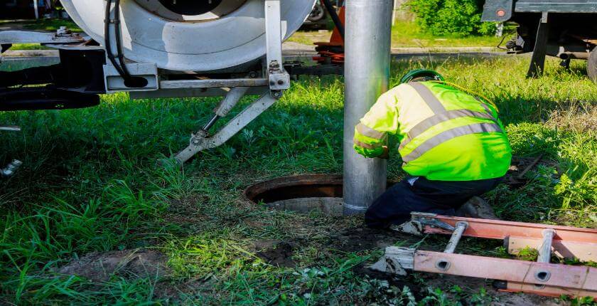
Can Drain Locations Be Mapped Without Excavation in Glasgow?
Our GPS drain surveys in Glasgow are completed without any digging.
We use CCTV inspection systems and sonde tracing tools inserted through existing manholes and access points, capturing accurate pipe routes and depths that are then geo-positioned using GPS technology.
Do GPS Drain Surveys in Glasgow Identify Foul, Surface, and Combined Systems?
Our GPS drain surveys in Glasgow classify connected systems as foul, surface water, or combined, and also document related infrastructure such as soakaways, interceptors, and outfalls.
This differentiation is vital for compliance, drainage strategy design, and asset management.
How Long Does a GPS Drain Survey Take for Sites in Glasgow?
Most residential GPS drain surveys in Glasgow are completed in a few hours.
Larger commercial or multi-building sites may require 1 to 2 working days depending on the number of drains and complexity of routing.
We aim to issue completed reports, including site diagrams, geo-referenced data, and invert levels, within 2 to 3 working days.
Are GPS Drain Survey Reports in Glasgow Suitable for Planning and Building Control Use?
Our GPS drain survey reports in Glasgow meet requirements for building control submissions, planning approvals, and coordination with utilities.
Reports feature pipe layout, direction, size, cover/invert levels, and material type and are available in CAD, PDF, or GIS-compatible formats.
What Technology Is Used for GPS Drain Surveys in Glasgow?
Our GPS drain surveys in Glasgow use the following tools and systems for precision data capture and reporting:
- CCTV drain cameras – For internal pipe inspection and alignment confirmation.
- Sonde tracers and locators – To follow pipe routes and measure depth from the surface.
- GPS survey units – To map surface-level drainage assets and pipe routes with geo-coordinates.
- Digital depth gauges – For logging invert and cover levels.
- CAD and GIS software – For generating clear, compliance-ready drawings and data outputs.
How Do Surveyors in Glasgow Ensure Accuracy in Confined or Complex Drain Systems?
We use push-rod and crawler CCTV units to access restricted or curved pipework during GPS drain surveys in Glasgow.
For confined, deep, or unsafe spaces, our team follows strict entry protocols using tripod systems, gas detection, and harnessed access, ensuring safe and accurate data collection.
Contact GPS Drain Survey to arrange a consultation or book a site inspection in Glasgow.
Find More Info
Make sure you contact us today for a number of great gps drain survey services in Glasgow.
For more information on gps drain survey in Glasgow , fill in the contact form below to receive a free quote today.
★★★★★
“The GPS drain survey gave us a clear and precise map of our drainage network, invaluable for our renovation project.”
Martin O’Connor
Glasgow
★★★★★
“Accurate results and a professional team. The GPS mapping made future maintenance planning so much easier.”
Helen Bradshaw
Glasgow